
Canoeing
There are few things as close to nature as gliding along in a canoe and hearing only the slow rhythmic sound of the paddles. With the help of the canoe, you can quietly glide along and get close to the wildlife in the water or along the riverbank.
The opportunities to experience this in Skellefteå are also almost endless. There are several nice rivers that offer good opportunities for paddling and also hundreds of lakes of varying sizes that are perfect for a canoe trip.
Skellefteälven
Enjoy the transformation of nature, a journey from forest landscape to city!
With this guide we want to give you, Skellefteälven's guest, a description of the river and its various stretches. Below you will find recommended paddling tours, choose tour by difficulty, length or sights.
Read more about the different rivers and find the paddling route that suits you!
Renström is located about 2 miles west of Boliden. This paddle is a nice trip through Västerbotten's forest and river landscape. Along the river you will find several nice resting places and small beaches. It is possible to look at old trapping pits and places where tar has been produced. The tour is free of rapids, and in places the river is quite wide, which can cause high waves to form when the wind blows.
Water type: River, seal
Difficulty: Easy/medium
Length: 12 kilometers
Drop: -
Time: 2-4 hours (Kayak)
| No. | Information |
|---|---|
| 1 | 0 km IP - RenströmThere is a rest area and a fireplace at the launch site. |
| 2 | 5 km Renfors, Stenuddens rest areaHere on the north side you will find a hut and shelter with a fireplace and there is also the possibility to go to the toilet. |
| 3 | 12 km UP - Båtforsen power stationPaddle into the canal at the power station on the north side to take up the canoe. Here there is a small pier, paddle into the bay that is formed and pick up the canoe on the pier so as not to get too close to the power station. |
%20Renstr%C3%B6m%20-%20B%C3%A5tforsens%20kraftstation%20ny%20_Sida_3.webp)
Before launching the canoe, take the opportunity to visit the Finnfors power plant museum, which offers an interesting insight into the history of hydroelectric power plants. For those who want a little adventure, you can go on a trip into the forest to Finnforsrövarnas cave.
The paddle trip starts at a nice rest area and takes you on to Granfors where you can fill water in cold springs.
Type of water: River, seal
Difficulty: Easy/medium
Length: 5 kilometers
Drop: -
Time: 1-2 hours (Kayak)
| No. | Information |
|---|---|
| 1 | 0 km IP - Finnfors rest areaLaunch on the south side of the river after Finnforsfallets power station. Turn left just after the fenced power line facility, here you will find both a shelter and a fireplace. |
| 2 | 4 km GranforsHere it is possible to fill up water in cold springs. Those who want to visit Finnforsrövarnas cave can from here take a demanding effort of about 1 km to get there. |
| 3 | 12 km UP - Båtforsen power stationTake the canoe up on the north side in the small bay. |
%20Finnforsfallets%20kraftstation%20-%20Granfors%20kraftstation_Sida_3.webp)
This is a pleasant day trip through the countryside and the city that offers many interesting and pleasant resting places depending on your interests. Put in the canoe at Mobackendammen, which you find 5 km west of Skellefteå, and travel through lush surroundings. The trip offers many possibilities and variations, it can be shortened or extended and paddled all the way to the sea.
Water type: River, seal
Difficulty: Easy
Length: 12 kilometers
Drop: -
Time: 3 hours (Kayak)
| No. | Information |
|---|---|
| 1 | 0 km IP - MobackenAt present, it is difficult to launch the canoe at Mobacken as the terrain is a bit rough. While waiting for canoe piers, it is recommended to launch the canoe at Kyrkholmen. When launching the canoe at Mobacken, this is done on the north side, where you will find both a shelter and a fireplace. |
| 2 | 2 km Rovön, LejonströmsbronA popular place to have a picnic, from here you can see the Lejonströmsbron, a wooden bridge that is now a cultural monument. |
| 3 | 3 km IP/UP - KyrkholmenIP/UP to the left of the bridge if you want to paddle in the area around the islands and the city. If you come paddling, you will see how several islands appear, the first is Kyrkholmen and here freshly baked waffles are served in summer. |
| 4 | 4 km Central cityIt is possible to moor your canoe in the city center. Nearby you will find the city park and other attractions that the city offers. |
| 5 | 5 km ManhemskajenIf you want to make a shorter trip, a good place to take your canoe is on the north side. |
| 6 | 9 km Norra TuvanHere it is possible to end the canoe trip on the north side at a slope before the houses. Here you will find Tuvagården which serves coffee during the summer. |
| 7 | 12 km UP - BergsbydammenKeep to the north a good bit before you reach the dam, the pick-up point is inside the bay. |
%20Mobacken%20-%20Bergsbydammen%20ny_Sida_3.webp)
The route is a nice continuation of the route Mobacken - Bergsbyn. This is a shorter day trip with nice stops. Swim at Gunsen or stop at the Kajutan café for a cup of coffee. See also the route Småälvarna/Innerviksfjärden.
Water type: River, seal
Difficulty: Easy
Length: 6 kilometers
Drop: -
Time: 2 hours (Kayak)
| No. | Information |
|---|---|
| 1 | 0 km IP - BergsbydammenPut in the canoe on the north side. Keep to the north side a bit before you enter the channel. |
| 2 | 2 km Channel to InnerviksfjärdenThe channel to the small rivers can be found on the south side of the river (at the power line). Here you can paddle in to get to Innerviksfjärden. |
| 3 | 3 km UP - StackgrönnanOn the south side you will find the café Kajutan, here you will find the Skellefteå area's famous shrimp sandwiches and if you are lucky, dancing is offered on the bridge. |
| 4 | 3 km Klemensnäs / Gunsen boatyardOn the north side you will find a suitable place to rest, a cool dip or to finish the canoe trip. |
| 5 | 6 km UP - KanotuddenAs you approach Kanotudden, the river meets the sea. This can create high waves, to avoid them keep to the northern edge. |
This tour offers you to put in and take out the canoe in the same place. Either you start at Stackgrönnan (south side) or Gunsen (north side) and paddle a bit upstream to get to the canal. The canal is narrow and lush, along the tour
there is a rest hut for those who want to go ashore and take a coffee break. Innerviksfjärden is a nature reserve of 1530 ha where 190 bird species have been noted, of which about eighty are breeding birds. During the period 15/4-1/6 you are not allowed to stay here except for specially marked paths.
Water type: River, seal
Difficulty: Easy
Length: 6-18 kilometers
Drop: -
Time: 1-3 hours (Kayak)
| No. | Information |
|---|---|
| 1 | IP UP - Stackgrönnan (south side) |
| 2 | IP UP - Klemensnäs/ Gunsen båtplats (north side)Paddle upstream a little bit to find the canal on the south side. |
| 3 | Channel towards Innerviksfjärden |
| 4 | Rest areaThe first shelter that you come to is a bit nicer than the others, the possibility to grill is available at both of them. |
| 5 | Rest areaSoon you will reach the Innerviksfjärdarnas nature reserve. When you reach the bay, you can choose whether you want to paddle the same way back or take a longer trip around Örviken, keeping in mind that the river meets the open sea. |
| 6 | UP - Innerviksfjärden / Kanotudden / Gunsen / StackgrönnanYou can choose to end your trip in Innerviksfjärden or paddle around Örviken's cape to get up along the river back to the place where you put in the canoe. The distance back to the starting point is about 16 km. Please note that outside Örviken is open sea which means that it can be windy. |
.webp)
Skellefteälven is the largest river in the municipality and since 1908 it has been developed in several places for electricity production. The river's source flow starts at the Norwegian border northwest of Vuoggatjålme and then flows 440 km before it meets the sea in the Gulf of Bothnia. At the beginning of the river, nature offers forest landscapes and traces of ore mining. Gradually the forest landscape changes to countryside and eventually to town.
Along the entire river you will find beautiful resting places and close to the city you will find several gems. Why not eat your picnic on Rovön or travel past Bergsbydammen and stop at café Kajutan to try the famous shrimp sandwiches. There are many suggestions for rest stops, and the only limit is your imagination. Along the Skellefteälven river there are several tour suggestions, choose between making shorter day trips or longer tours with an overnight stay.
The average water flow in the river is 153 cubic meters per second. In some places the river is very wide, in some places 5-20 meters high and steep banks have been formed when the river has cut into the ground. Nipas and ravines are common along the whole river and in the upper parts the river is surrounded by woodland. In the lower parts, at the height of Klutmark, the landscape becomes considerably more open and here the Skellefteå River is surrounded by arable land and buildings.
For those interested in fishing, the Skellefteå River offers trout, grayling, brook trout, pike, perch, whitefish, roach, burbot, burbot, burbot, stone pike, gers, sturgeon and bream.
Byske river
Nature's presence is palpable, the river has chosen its own path and you are welcome to try it.
With this guide we want to give you, the guest of the Byske River, a description of the river and its different stretches. Below you will find recommended paddling tours, choose a tour according to difficulty, length or sights.
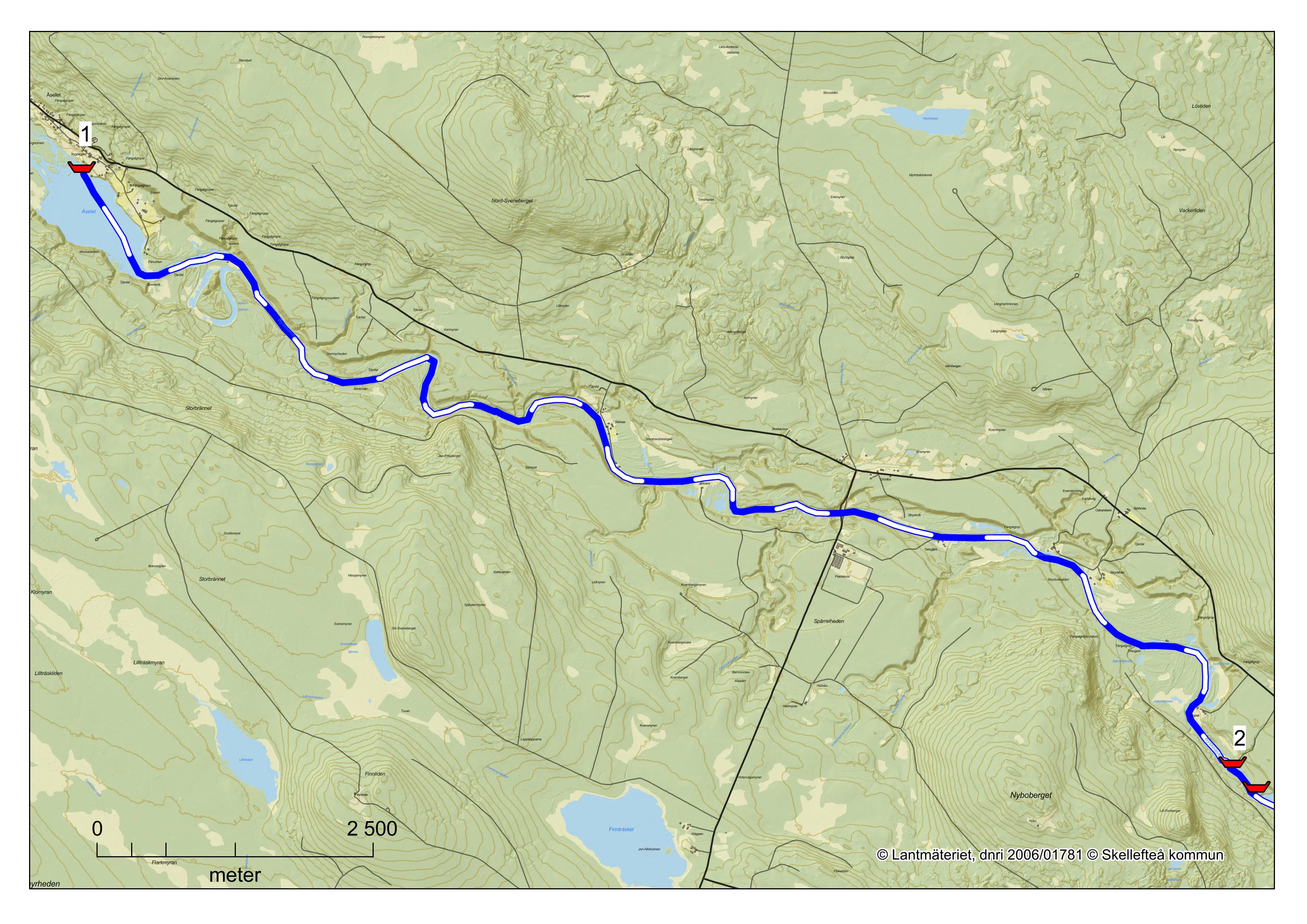
A beautiful paddling trip through a classic forest landscape where the river flows in beautiful meander bends and the riverside is adorned with nipas in some places. This paddling trip is a suitable and nice day trip for the inexperienced paddler in an open canoe. At
Småforsarna you will find a nice rest area and for those who want to spend the night this is the perfect place. The route can be paddled all season. Those who want a longer trip can continue on to Fällfors.
Type of water: Sel
Difficulty: Easy
Length: 14 kilometers
Drop: 2 meters
Time: 4 hours (Kayak)
| No. | Information |
|---|---|
| 1 | IP - ÅseletThe launch site in Åselet is after the river delta flows into a smaller lake. Park at the village hall and then walk down to the river. |
| 2 | UP - SmåforsarnaAt Småforsarna there is a shelter and the opportunity to go to the toilet. Here there are also good opportunities to stay overnight. |
Småforsarna to Fällfors is a suitable and nice day trip for inexperienced paddlers in open canoes. Passing Småforsarna requires two lifts or one long lift, a canoe cart makes it easier. On the north side of the river there is a path to take the canoe downstream.
The river flows through the landscape in meandering arcs. Along the stretch you will see some sandbanks and in the vicinity you can find ancient remains. The stretch can be paddled throughout the season.
Type of water: Sel, rapids
Difficulty: Easy
Length: 12 kilometers
Drop: 5 meters
Time: 4 hours (Kayak)
| No. | Information | Class | Risk class | Length |
|---|---|---|---|---|
| 1 | IP - Småforsarna | |||
| 2 | Småfors 1Path to carry the canoe is on the north side. | 1+ | 1 | 200 m |
| 3 | Småforsarna | 1+ | 1 | 200 m |
| 4 | UP - FällforsBe careful at the pick-up point in Fällfors not to end up in Fällforsen. The rapids are completely impassable and the canoe must be picked up in good time to avoid being sucked into the rapids. The pick-up point is right next to Fällfors camping. | |||
| 5 | FällforsenThe rapids are beautiful to look at but completely harmless. In the immediate vicinity there are good paths to take the canoe instead. | 6 | 5 | 300 m |
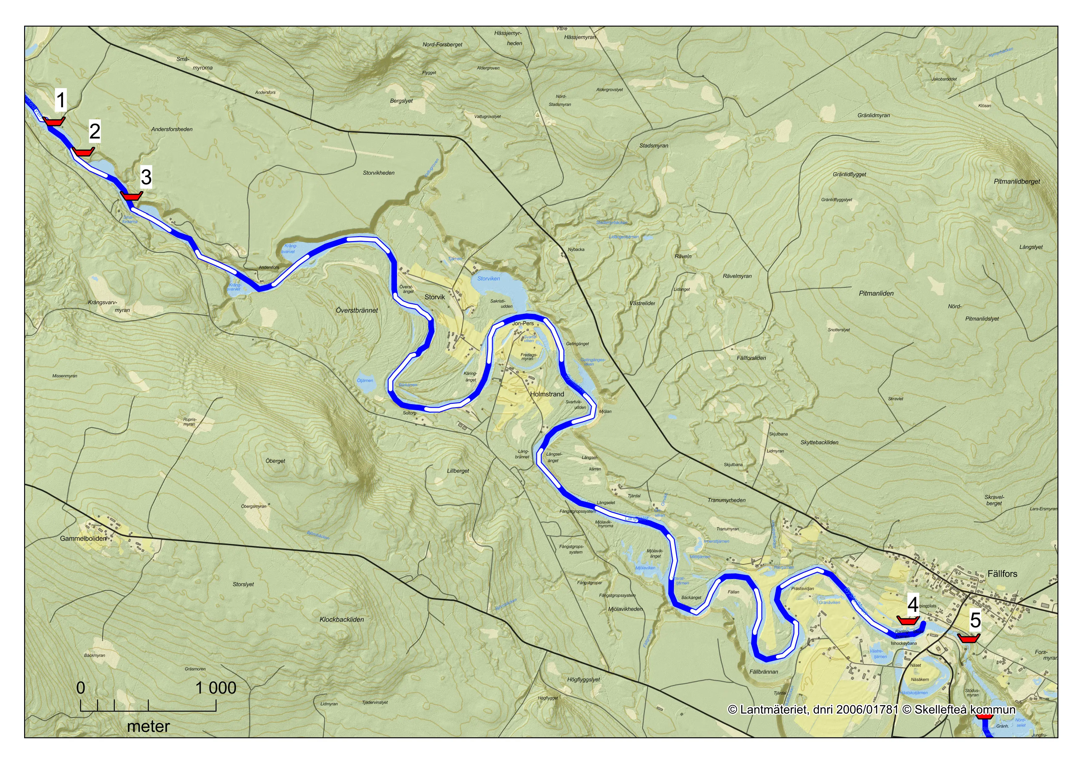
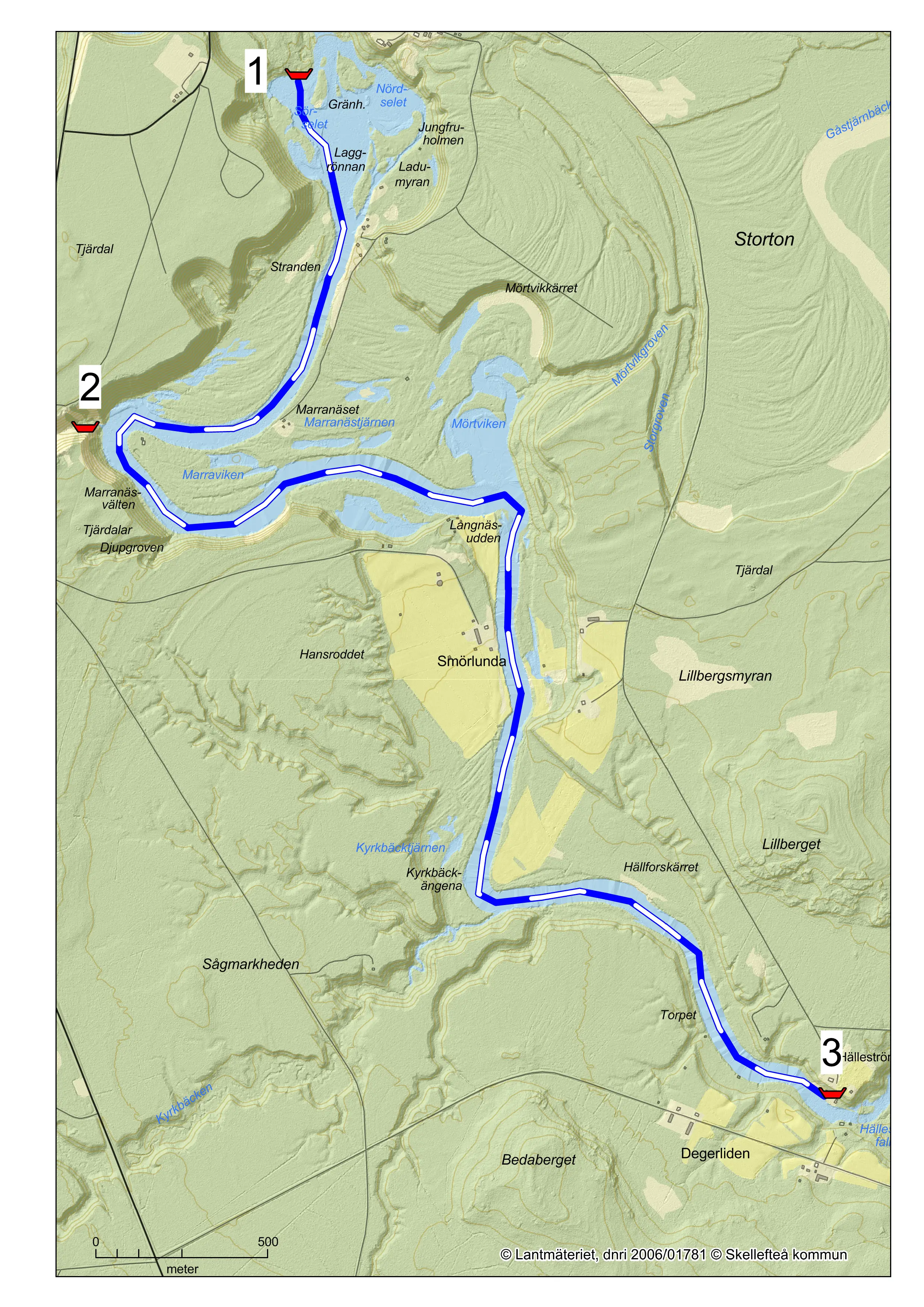
Fällfors to Hälleström is suitable as a short day trip for inexperienced paddlers in open canoes. The route can be paddled throughout the season. Pay attention when approaching the Hälleström waterfall and take the canoe to the left well before the waterfall. Halfway you will find Maransvältan, a 150 meter long and 100 meter wide ravine with 40 meter high steep walls, an interesting feature on the journey along the scenic Byske River.
Type of water: Sel
Difficulty: Easy
Length: 6 kilometers
Drop: 2 meters
Time: 2 hours (Kayak)
| No. | Information |
|---|---|
| 1 | IP - FällforsThe launch site is after Fällforsen on the south side of the river. Follow naturstigen to get down to the river. |
| 2 | MaranäsvältanHere a spring vein has eroded a deep ravine in about 60 years. |
| 3 | UP - HälleströmPay attention to the pick-up point in Hälleström so as not to get too close to the Hälleström waterfall. Take up in good time on the left side. |
The Byske River starts its journey in the municipality of Arvidsjaur. It has time to give rise to several "eye-popping" sights before it majestically says goodbye, by throwing itself into the Gulf of Bothnia with power from the last rapids in Byske community.
The Byskeälven's two largest source lakes, Långträsket and Västra Kikkejaur, provide the river with most of its water during its initial course in the municipality of Arvidsjaur. But the Byskeälven proper takes its shape downstream of Lake Arvidsjaur and gets its name downstream of Kilverjaure.
Within Skellefteå municipality, the river drops 295 meters over a distance of about 10 miles - a drop that guarantees scenic scenes and powerful rapids. During the first mile, the historically interesting Garaselet is encountered, which was home to people as far back as 8,000 years ago. This is followed by almost three miles of steeply descending river section, including several wild rapids, before the river takes a break and gathers new strength in the calm Åselet.
From Blankselet down to Åselet, the river passes through the ever-changing delta area formed when the sea was at its highest, during the melting of the inland ice. The large amounts of stone and gravel are easily movable and constantly create new river environments under the influence and pressure of the river. These environments are perfect spawning grounds for salmon and this is also where the famous Byskeälven salmon have one of their most important breeding areas in the river.
This is also the botanically richest area of the river, well worth a visit. Near the village of Åselet there are habitats for the protected orchid norna. North of the village is Brännliden nature reserve where you can hike through a magical primeval forest environment. This is perhaps the oldest coniferous forest in the municipality.
During the Åselet-Fällfors stretch, the river consists mainly of calm seals where it slowly and sharply winds its way downstream. The winding curves of the river are also called meanders, and create a constant change in the landscape. There is also the fantastic Marranäsvältan, a 160-meter-long erosion ravine, constantly growing as the groundwater brings sandy material to the river.
During a visit to Fällfors it is almost impossible to miss the rapids that gave the village its name - Fällforsen. In the middle of the village is the Fällfors Falls, which has always been a migration barrier for salmon and trout. Today there are salmon stairs in the waterfall that make it easier for the fish to reach the fine spawning areas mentioned earlier. During July there are good opportunities to see a wild salmon jump in the waterfall or swim past in the salmon observatory. Be sure to visit the falls in mid-May when the spring flood offers a powerful spectacle, with up to 200 m3 of water per second rushing down the falls.
Salmon fishing is one of the hallmarks of the Byske River and is mentioned in documents as early as 1337. Today, the sport fishing for salmon is considered one of the best in Sweden. In addition to salmon, the river also has good stocks of grayling and trout. Fishing is well organized along the entire river and it is easy to buy a fishing license and try your luck. The river also has abundant stocks of the protected river pearl mussel, which previously attracted pearl fishermen to the area.
Timber rafting took place in the Byske River from the late 1700s until the late 1960s. There are still remnants of this era in the form of stone coffins along the banks. Most of the river's rapids have been restored to their former natural appearance in recent years. This environment is much more inviting to the inhabitants who spend their lives in the river, including fish, insects and mammals. These mammals include the otter, which has one of the most important areas in the Byskeälven water system in the municipality.
The Byske River is easily accessible, as a road runs on its northern side from Byske up through Arvidsjaur municipality.
Route description
Fällforsen:
Drive about 30 km west from the E4 in Byske. Turn left in Fällfors in the middle of the community and go another 300 m down to the river and Fällforsen. Fällfors Falls is within walking distance just downstream of the road bridge.
Åselet (village):
Turn off the E4 in Byske in the direction west towards Fällfors. Continue the road through Fällfors and drive another 20 km.
River Bure
Travel through the Västerbotten countryside and beautiful lakes, feel the smell of bygone times.
With this guide we want to give you, Bureälven's guest, a description of the river and its different stretches. Below you will find recommended paddling tours, choose tour by difficulty, length or sights. On the right you will find a description of the different classes mentioned in the guides and a map of the canoe routes.
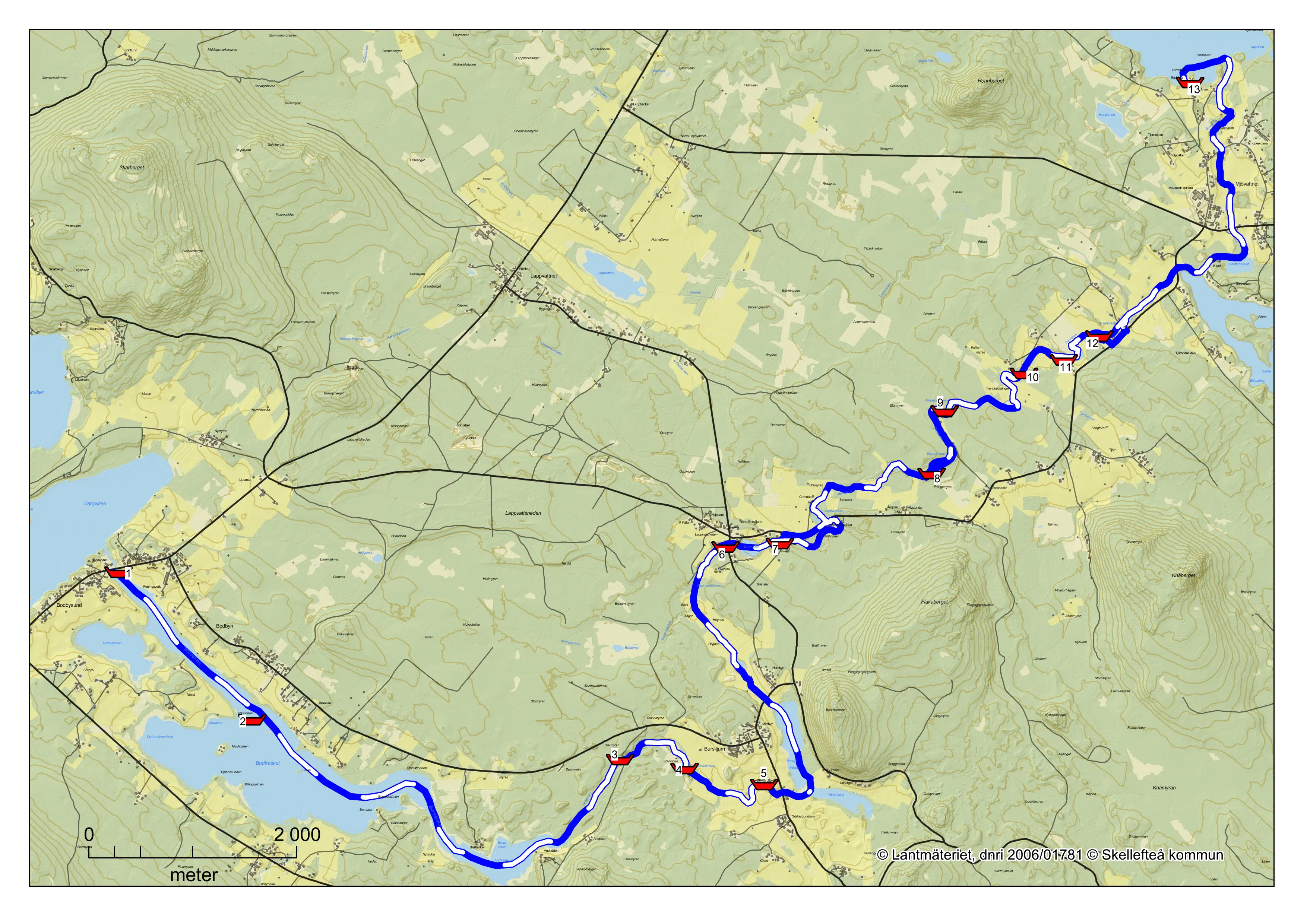
Bodbysund to Mjödvattnet is a long day trip or an overnight trip. The river flows through an agricultural environment with a varied lake, small rapids and seals. Some short lifts past ponds and rocky rapids are required. The route is recommended for beginners and experienced paddlers in Canadians. At low water, the route is less suitable for paddling due to a lot of rocks. Since water levels can vary between the dams, reconnaissance of the rapids should always be done.
Type of water: Lake, seal and rapids
Difficulty: Easy/medium
Length: 23 kilometers
Drop: 38 meters
Time: 6-8 hours (Kayak)
| No. | Information | Forest class | Risk class | Length |
|---|---|---|---|---|
| 1 | IP - BodbysundThe loading site is on the left when you come from Skellefteå. | |||
| 2 | Horkalln´On the island you can go ashore and there is a shelter and barbecue area. | |||
| 3 | SvarttjärnsdammenHere the canoe must be lifted up before the dam and put in again after the dam. Carry the canoe on the left side, here there is the possibility of grilling. For those who want to paddle a shorter trip, it is possible to end the trip here. | |||
| 4 | Gammelroddforsen | 2 | 1 | 200 m |
| 5 | The mill in Bursiljum, Kvarnforsen rapidsLift the canoe past the mill on the left side. Put the canoe back into the canal after the mill. When you reach Bursiljeträsket, keep left to follow Bureåälven to Mjödvattnet. | 3 | 2 | 200 m |
| 6 | The sawmill in LappvattshedenNow you pass Folkparken in Bursiljum, a gem among the folk parks in Västerbotten. The canoe should be carried which is done on the right side. | 2 | 2 | 200 m |
| 7 | The mill in LappvattshedenOnce again it is time to pick up the canoe, this time on the right side to be put in again after the mill for those who want to paddle the rapids. Those who want to avoid the rapids can carry the canoe along the road for about 300 m and put the canoe in at the bridge. | 2 | 2 | 200 m |
| 8 | StormyrforsenTake the canoe up in good time before the dam/power station on the headland on the right-hand side. If you want to paddle in the rapids, paddle in the middle. Launch the canoe on the right side after the power station. | 3 | 2 | 300 m |
| 9 | FäladsforsenHere are three smaller rocky rapids. | 1 | 1 | 100 m |
| 10 | KattermyrforsenRocky rapids. | 1 | 1 | 100 m |
| 11 | TjärnforsenRocky rapids, here it is recommended to keep to the left edge. | 1 | 1 | 100 m |
| 12 | Kvarnforsen in TjärnLift the canoe on the right side, canoe trolley makes it easier. There is a rest area where you put the canoe back in. | 3 | 2 | 300 m |
| 13 | UP - Mjödvattnet Easy pick-up at the beach in Mjödvattnet. |
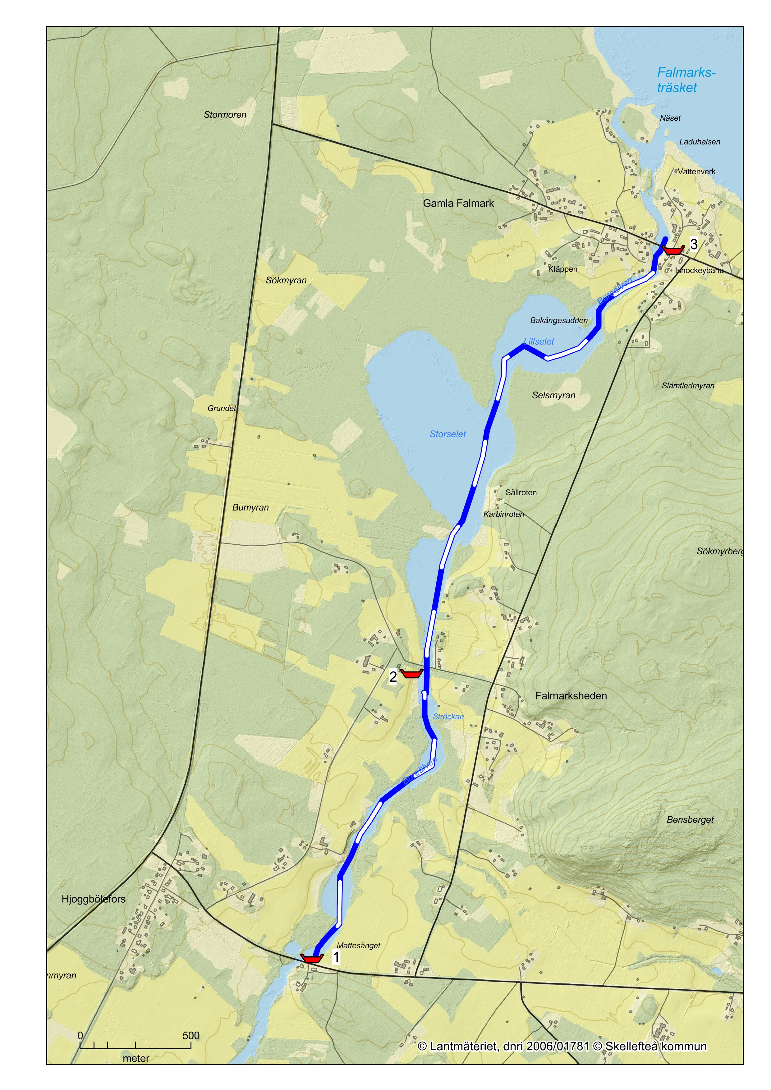
Hjoggbölefors to Falmarksträsket is suitable as a short day trip. You paddle through beautiful countryside with a nice resting place along half of the trip.
The route is recommended for beginners in Canadian canoes. At low water, the route is less suitable for paddling due to a lot of rocks.
Water type: Lake, seal, rapids
Difficulty: Easy
Length: 4 kilometers
Drop: 4 meters
Time: 1 hour (kayak)
| No. | Information |
|---|---|
| 1 | IP - Hjoggbölefors |
| 2 | Resting place After about half the distance you will find a shelter with the possibility to grill. |
| 3 | UP - Falmarksträsket Pick up the canoe at the bridge before you reach the swamp. |
The tour starts in the small idyllic village of Bodbysund and then travels along the river through lakes and small rapids. Along the trip you will see parts of Västerbotten's cultural heritage, pass the old mill in Bursiljum and the dance hall that still offers dancing in the summer, well into the small hours. On beautiful summer days, the views along this canoe trip are part of Sweden's most beautiful landscape.
The Bure River as a whole, with its many lakes and not too difficult rapids, is a suitable river for Canadians. Due to insufficient water flow during normal summer water, the best time for paddling is in spring and during heavy rainfall.
Bure River is one of the smallest forest rivers in Skellefteå municipality and flows up just south of Burträsk and flows about 10 miles later at Bureå into the sea, about two miles south of Skellefteå. The average water flow at the outlet is about 11 cubic meters per second. A characteristic feature is the river's many large lakes.
The river is regulated for hydropower purposes and has two power stations, Mjövattsforsen and Falmarksforsen hydropower stations, the latter being a definite barrier to fish migration. As a result of the regulation, the water flow in the Bureälven is normally relatively even, with a lower spring flow and higher winter flow than normal.
Pike, pike, perch and the Swedish crayfish are the species that primarily characterize the Bureälven as a fishing river. The species occur in strong populations. The pike-perch is unique in that it is actually outside its actual range. Incidentally, the Bureälven water system is the only water in Västerbotten where there are zander. Through active fisheries management work, stocks of salmon and sea trout are now being restored in the lower parts of the river.
Important information when paddling
Learning to paddle a canoe takes a while. It may be wise to start on calm water and preferably in the company of someone who has been there before. A life jacket is of course a must for both young and old. Going out on the sea or river rapids requires a great deal of knowledge and the right equipment.
Safety and security
- Make a habit of always scouting all rapids, as this guide cannot replace your own observations on the spot. For example, it does not take into account changes in the river that have occurred after the survey, such as moved rocks, fallen trees, etc.
- If you end up in the water, never try to stand up in the rapids. The bottom is covered with stones, which makes it easy to get your feet stuck. Instead, float with your feet downstream until you reach calm water.
- If the water temperature is low, you should wear a wetsuit, as you will quickly get cold in cold water.
- Never paddle alone.
- Use a life jacket designed for the purpose.
- Leave a travel message.
- Do not overestimate your ability, experience and knowledge.
- Make sure that any luggage is secured.
Equipment
Paddler's equipment:
- Life jacket
- Helmet (for rafting)
- First aid kit
- Throwing line
- Change of clothes and matches (packed waterproof)
- Chapel (for paddling)
Equipment of the canoe:
- Bow and stern lines to be used for towing and mooring.
- Spare paddle
- Throwing line
- Repair equipment
Explanation of terms
Backwater: When running water is forced around an obstruction, calm water usually forms behind the obstruction.
Whirlpool: When water rushes over an obstruction, it creates a recirculation back against the current.
Suction waltz: A waltz with stronger and deeper recirculation.
Blue groove/tongue: In a rapid, there is usually a path where most of the water flows, forming a trail of water that does not contain as much air as the surrounding water. Blue trails are often a good and safe route to take in a rapids.
This guide uses a new two-part scale to classify the rapids. The scale is based on the international scale for the classification of rapids.
Some of the paddling trips are sometimes far from civilization, which means that it can take a long time to get help from outside in case of an accident. Take care!
The first number indicates a technical difficulty level, graded 1 to 6.
We have also used + and - to further refine this scale.
The second number indicates a risk level that tells us how serious a failure to navigate the rapids could be, such as having to swim.
Again, the scale goes from 1 to 6, with 1 being essentially harmless and 6 being considered fatal.
International scale for rapids:
- Flowing water with small waves and no major obstacles.
Can be paddled by beginners - Easy rapids with irregular waves that can break at the top and small rollers.
Few obstacles but not always easy to find the way. Some maneuvering may be required.
Can be paddled by intermediate paddlers. - Strongly rushing rapids with some small falls and large, irregular breaking waves and rollers. Obstacles and passages requiring maneuvering.
Considered the upper limit of what can be paddled with an open Canadian.
Can be paddled by experienced paddlers
Helmet, canopy and reconnaissance recommended. - Persistently difficult rapids with falls, large breaking waves, large rollers and strong eddies. Passages that require precise maneuvering in turbulent rapids.
Can be paddled by very experienced paddlers
Helmet, canopy and reconnaissance recommended. - Extremely difficult, persistent rapids with falls, large breaking waves, large rollers and strong eddies. Passages requiring precise maneuvering in very turbulent, steep rapids. Mostly "white water".
Can be paddled by experts
Helmet, canopy and reconnaissance are recommended. - As class 5 but even stronger currents and rollers. Large falls.
Can be paddled by experts
Helmet, canopy and reconnaissance recommended.
The difficulty of the rapids can vary with the water level. The classification refers to high water level. When talking about right and left in flowing water, it is always in the direction of the current.